Seattle to Las Vegas Road Trip: The Complete 7-Day Itinerary, Best Stops & Route Guide (2026)
The drive from Seattle to Las Vegas covers approximately 1,150 miles through five states, two of the country’s most dramatic mountain ranges, the deepest lake in the United States, and the hottest place on Earth. Done right – with the correct route, advance permits for the parks that require them, and a realistic day-to-day plan – this is one of the great American road trips. Done wrong, it’s a grind down an interstate with missed opportunities on every side.
At Seattle Black Limo, our chauffeurs drive the Pacific Northwest and Pacific Coast corridors year-round. We know which stretch has no fuel for 90 miles, which parks turn away hundreds of visitors a day without reservations, and exactly which departure time from Seattle keeps you ahead of Cascade traffic. This guide puts all of that road knowledge to work for you.

Quick Facts: Seattle to Las Vegas Road Trip at a Glance
One important clarification before you plan: the trip is not “about 1,000 miles” as many travel articles incorrectly state. Google Maps consistently returns 1,140–1,160 miles depending on your exact starting point in Seattle and route selection. Budget your fuel accordingly.
Choosing Your Route: I-5 West Coast vs. the Eastern Desert Alternative
Two genuinely different road trips exist between Seattle and Las Vegas. The route you choose determines which landscapes you wake up to and which national parks you walk through. Neither is wrong – they just show you different Americas.
Route 1 — I-5 West Coast Route
- Distance: ~1,150 miles
- Drive time: 17–19 hours total
- Path: Seattle → Portland → Eugene → Medford → Redding → Sacramento → Death Valley → Las Vegas
- Highlights: Columbia River Gorge, Crater Lake (side trip), Shasta, Death Valley
- Terrain: Coast ranges, Central Valley, Mojave Desert
- Best for: Travelers who want more cities, more services, easier driving
Route 2 — US-97 / US-395 Eastern Route
- Distance: ~1,200 miles
- Drive time: 19–21 hours total
- Path: Seattle → Yakima → Bend → Klamath Falls → Reno → US-95 → Las Vegas
- Highlights: High desert, Cascade backsides, Great Basin, Lake Tahoe access
- Terrain: High desert plateaus, basin and range, Nevada desert
- Best for: Travelers who want isolation, big skies, fewer crowds
Yosemite National Park is frequently listed in Seattle–Las Vegas road trip articles, but it sits 280+ miles off the direct I-5 route.
If Yosemite is a priority, build 2 extra days into your itinerary and budget for the detour via CA-120. It is absolutely worth the extra mileage — but go in knowing it's a significant addition, not a roadside stop.
The 7-Day Seattle to Las Vegas Road Trip Itinerary
This itinerary follows the I-5 route – the most traveled and most service-rich path. Depart Seattle by 7:00am on Day 1 to beat the morning traffic through Tacoma and Olympia on I-5 South.
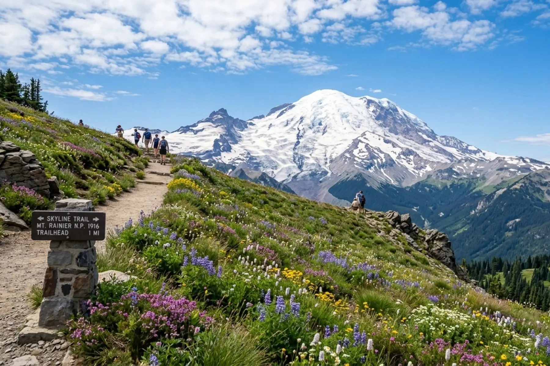
Seattle → Mount Rainier National Park
Mount Rainier is the right place to start — close enough for a relaxed morning departure, dramatic enough to establish the tone for the entire trip. At 14,411 feet, Rainier dominates the southern Cascade skyline and carries more glacial ice than any other mountain in the contiguous United States.
What to do:
- Drive the 12-mile Paradise Road to the Henry M. Jackson Visitor Center (open late May through mid-October, weather permitting).
- Walk the 5.5-mile Skyline Trail loop for glacier views, summer wildflowers, and a real sense of the mountain's scale.
- Wildlife sightings — deer, marmots, and occasionally black bears near the tree line — are common in early morning.
Practical Details:
- Timed-entry reservations required for Paradise corridor on busy summer weekends — check recreation.gov
- Fill your tank in Ashford before entering the park — no fuel inside
- Stay overnight at Whittaker's Motel in Ashford (~$120–$180/night) or backtrack to Packwood for more options
- The Cougar Rock Campground inside the park accepts reservations at recreation.gov ($30/night)
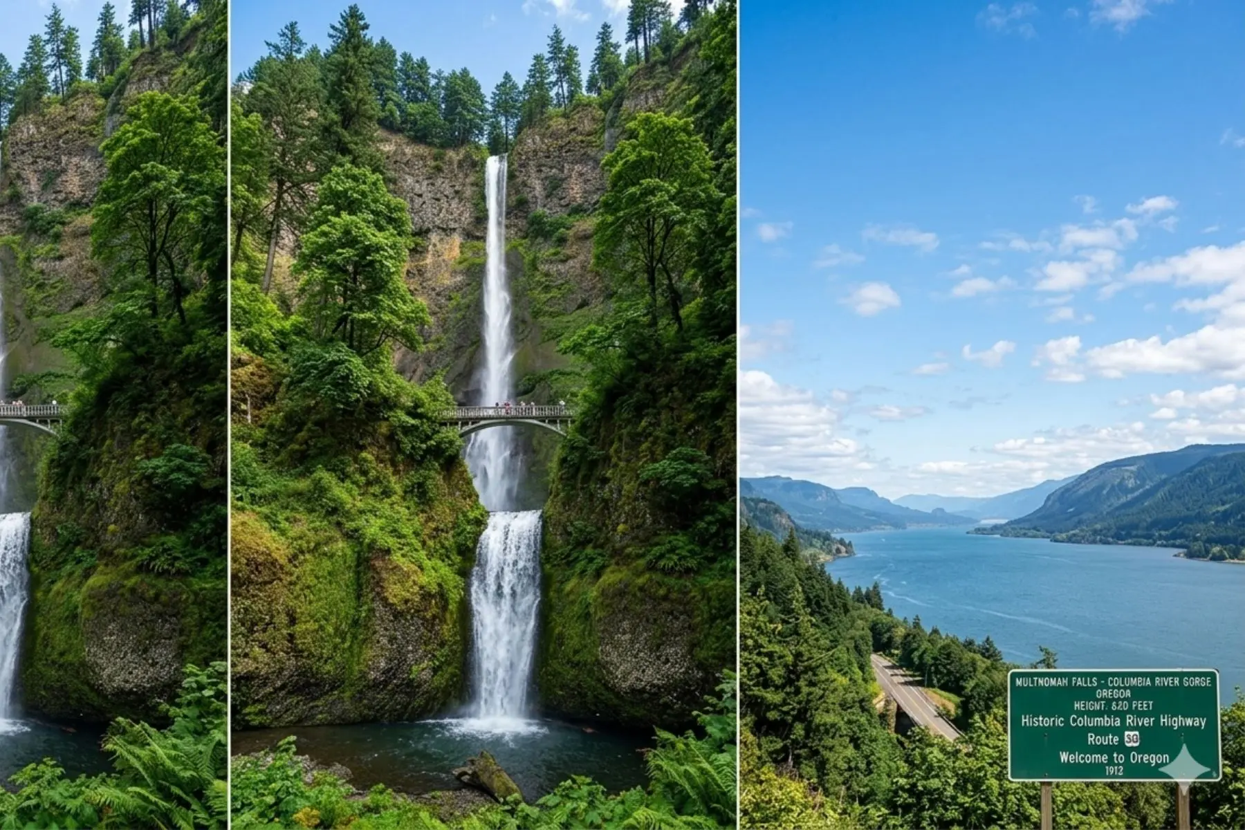
Mount Rainier → Columbia River Gorge → Eugene, OR
Drop south from Rainier on US-12 West, join I-5 South at Chehalis, and cross into Oregon through Portland. Before you push south toward Eugene, take the Historic Columbia River Highway (US-30) east from Troutdale for the best roadside scenery of the entire trip.
Other Gorge Stops Worth the Time:
- Crown Point State Scenic Corridor — 733 feet above the Columbia River, panoramic views with almost no hiking required
- Horsetail Falls — 2 miles east of Multnomah, far fewer crowds, equally dramatic
- Vista House at Crown Point — free, octagonal 1918 stone building with river views in every direction
Rejoin I-5 South at Cascade Locks. Push to Eugene or Roseburg for the night — both have solid motel options ($90–$160/night) and easy I-5 access for an early Day 3 departure.
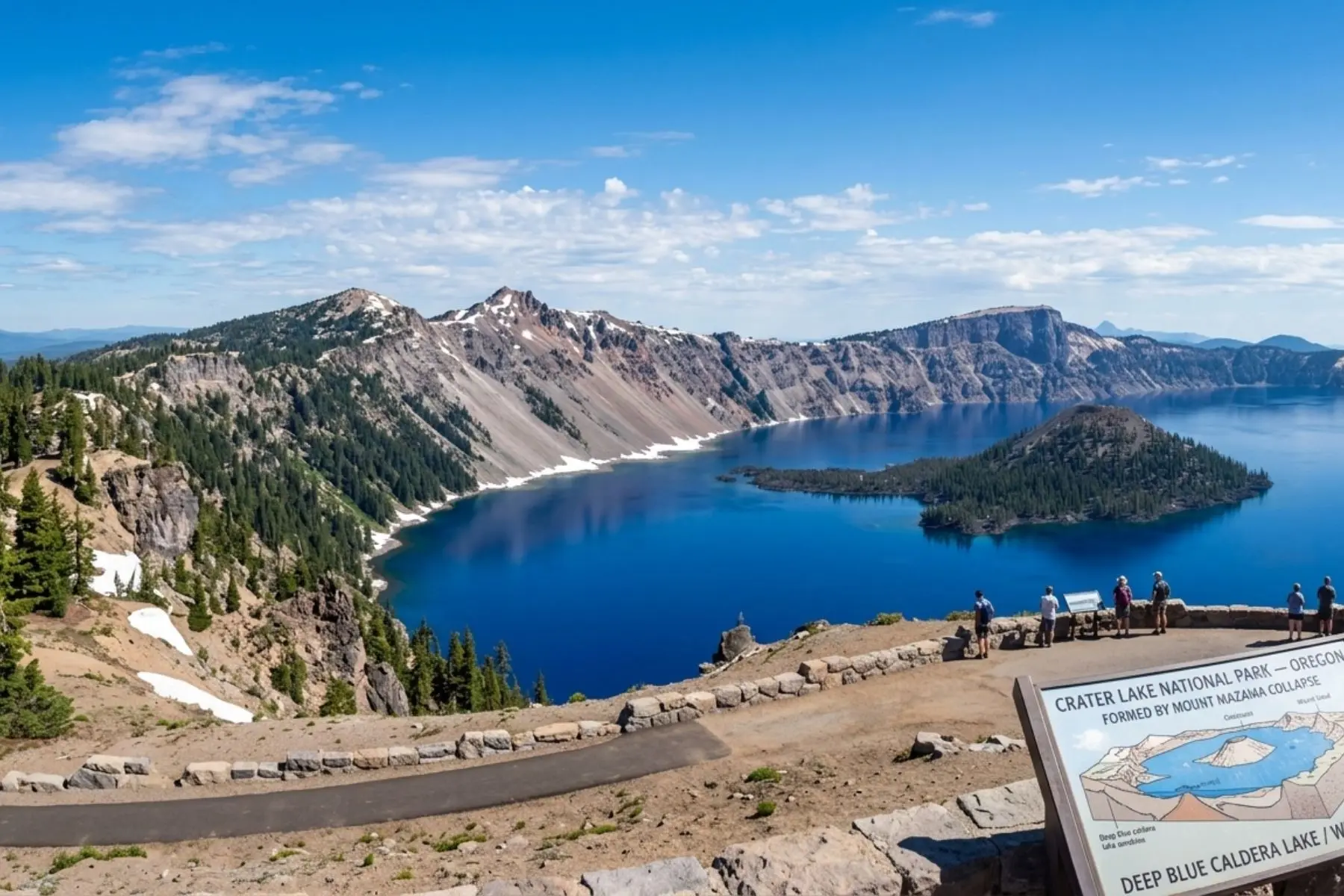
Eugene → Crater Lake National Park → Klamath Falls
Crater Lake is the most visually arresting stop on this entire road trip. The caldera formed roughly 7,700 years ago when Mount Mazama — a Cascade volcano standing nearly 12,000 feet tall — collapsed after a catastrophic eruption. What filled the crater is entirely fed by rain and snowmelt. No rivers flow in or out. The result is the cleanest, purest water in North America, producing that impossible shade of deep cobalt blue that photographs never quite capture.
What to Do at Crater Lake:
- Rim Drive — the 33-mile loop around the caldera rim takes 2–3 hours by car with stops. Open approximately late June through mid-October. Check current road status at nps.gov/crla before arriving
- Cleetwood Cove Trail — the only legal trail to the lake's edge; steep 1.1-mile descent, strenuous return. Boat tours to Wizard Island depart from the dock at the bottom
- Wizard Island boat tour — reserve in advance at craterlakelodges.com; limited daily spots
- Watchman Peak Trail — 1.6 miles round trip, best elevated view of the entire lake
Seasonal Closure Warning:
Crater Lake's Rim Drive closes mid-October and typically reopens in late June or early July, depending on annual snowfall. Even in summer, sections can close temporarily after overnight snow. Always check current conditions at nps.gov/crla the morning you plan to visit. If the Rim Drive is closed, the lake is still accessible via the North and South Entrances — but you see it from fewer vantage points.
Overnight in Klamath Falls ($85–$140/night for chain hotels) or backtrack to Medford for more restaurant options. Both set you up well for Day 4's push into Northern California.
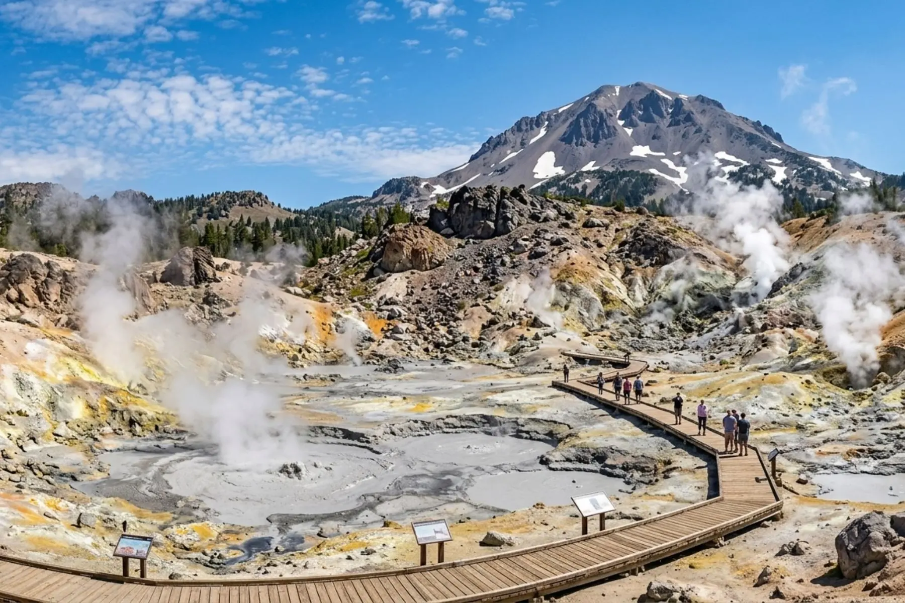
Klamath Falls → Lassen Volcanic National Park → Redding/Red Bluff
Lassen Volcanic National Park is the most underestimated stop on this road trip. While Crater Lake attracts the crowds, Lassen sits quietly 140 miles to the south, receiving a fraction of the visitors despite offering hydrothermal landscapes that exist almost nowhere else in the lower 48 states.
What to Do at Lassen:
- Bumpass Hell — 3-mile round trip trail through the largest hydrothermal area in the park. Boiling springs, steaming fumaroles, and sulfurous mud pots. Stay on the boardwalk — the crust is thin and the water below reaches 322°F
- Lassen Peak Trail — 5-mile round trip, 1,957 feet of elevation gain to the summit at 10,457 feet. Only for those who are acclimated and in good shape. Stunning views of the Cascades from the top
- Lake Helen — snow often persists into July; excellent early-morning photography
Push south on CA-36 to Redding after the park. Redding sits at the junction of I-5 and CA-44 and has abundant fuel, food, and hotel options. This is also your last comfortable urban stop before the route turns east toward Death Valley.
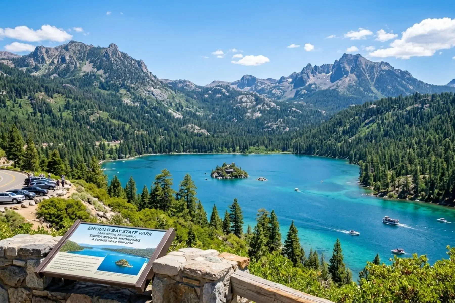
Redding → Sacramento → Lake Tahoe Area
Take I-5 South to Sacramento, then head east on US-50 into the Sierra Nevada. The climb from the Central Valley floor into the mountains on US-50 is itself a dramatic drive — you gain 6,000 feet in about 60 miles, the pines close in, and the temperature drops 20 degrees.
What to Do at Lake Tahoe:
- Emerald Bay State Park — the most photographed spot on the lake. Hike the 1-mile trail to Vikingsholm Castle at the water's edge ($15/vehicle state park fee)
- Sand Harbor State Park — best swimming and kayak launch on the Nevada side ($15/vehicle in summer, reserve timed entry on busy weekends)
- Tahoe Rim Trail — 165 miles total; even a 3–4 mile section from Heavenly Mountain Resort offers lake panoramas most visitors never see
- Kayak or paddleboard rental — South Lake Tahoe has multiple rental outfitters on the lake ($30–$50/hour)
Stay in South Lake Tahoe — the Nevada side has casino hotels that offer surprisingly good rates ($90–$200/night), and the state line location means you're positioned for a straightforward departure toward Death Valley on Day 6.
Lake Tahoe → Death Valley National Park → Pahrump
Take US-395 South from Tahoe through Reno, then head south on US-395 through the Owens Valley. The Bishop and Lone Pine stretch of US-395 — with the eastern face of the Sierra Nevada rising straight up on your right and the White Mountains across the valley — is arguably the most dramatic 100-mile highway drive in California.
CRITICAL: The 90-Mile Fuel Gap — Read This Before Entering Death Valley
- The stretch from Beatty, NV to Furnace Creek, CA via NV-374 and CA-190 is approximately 90 miles with no gas station
- Fill your tank completely in Beatty before entering — a half-full tank is not enough
- In summer (May–September), fuel demand at Furnace Creek spikes and pumps occasionally run dry — carry a 2-gallon emergency reserve if possible
- Cell signal is non-existent for most of this stretch — download offline maps on Google Maps or maps.me before you leave Beatty
Best Death Valley Stops (Visit Before 10am or After 4pm in Summer):
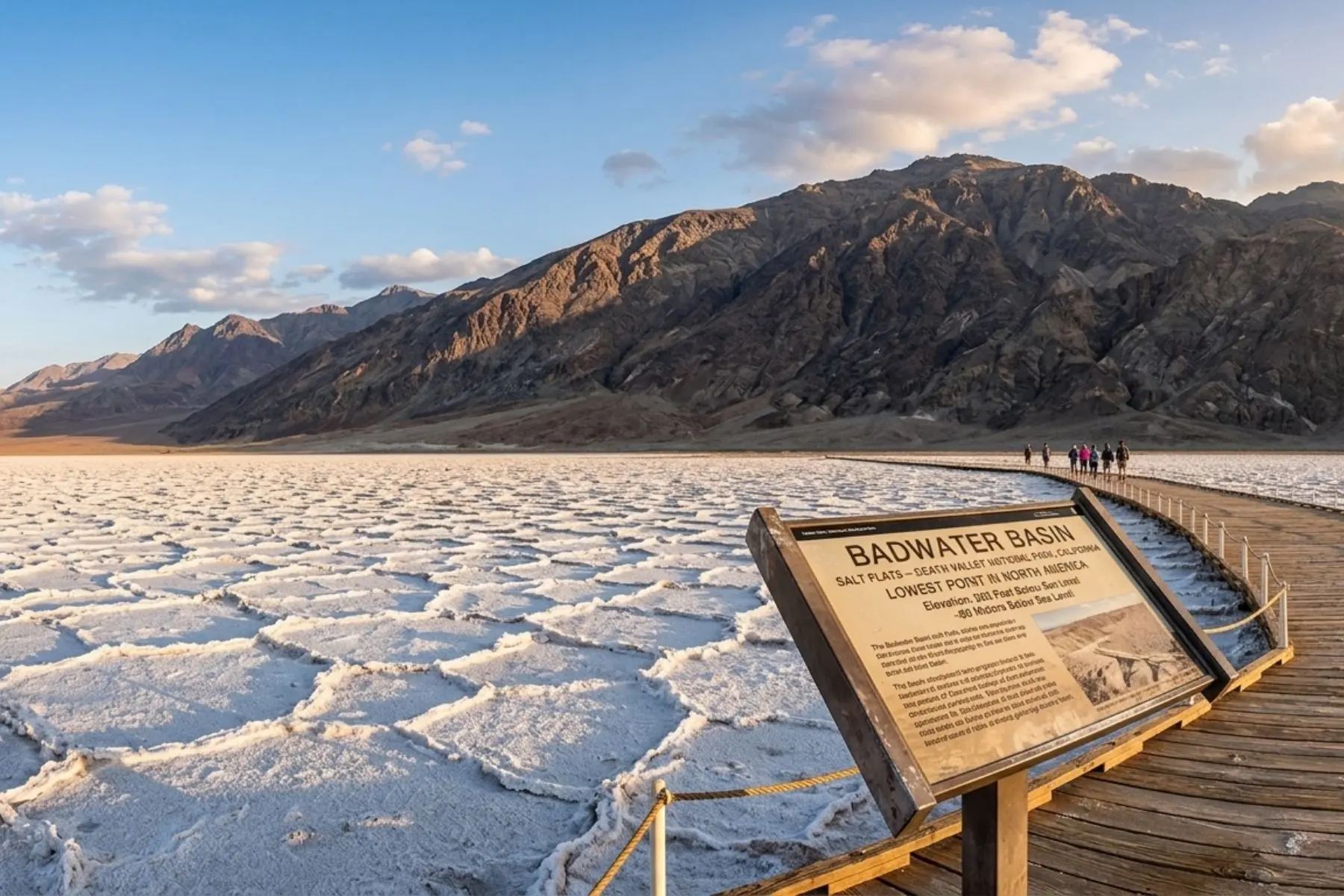
- Badwater Basin — walk out onto the salt flats for the most surreal landscape in North America.
- Mesquite Flat Sand Dunes — best at sunrise or sunset.
- Artist's Drive — 9-mile one-way scenic loop through multicolored hills.
- Dante's View — 5,476 feet above Badwater Basin for the best panorama.
Exit Death Valley east on CA-127 North toward Baker, then take I-15 North to Pahrump, NV. Pahrump offers budget lodging ($60–$100/night) and sits just 60 miles from the Las Vegas Strip.
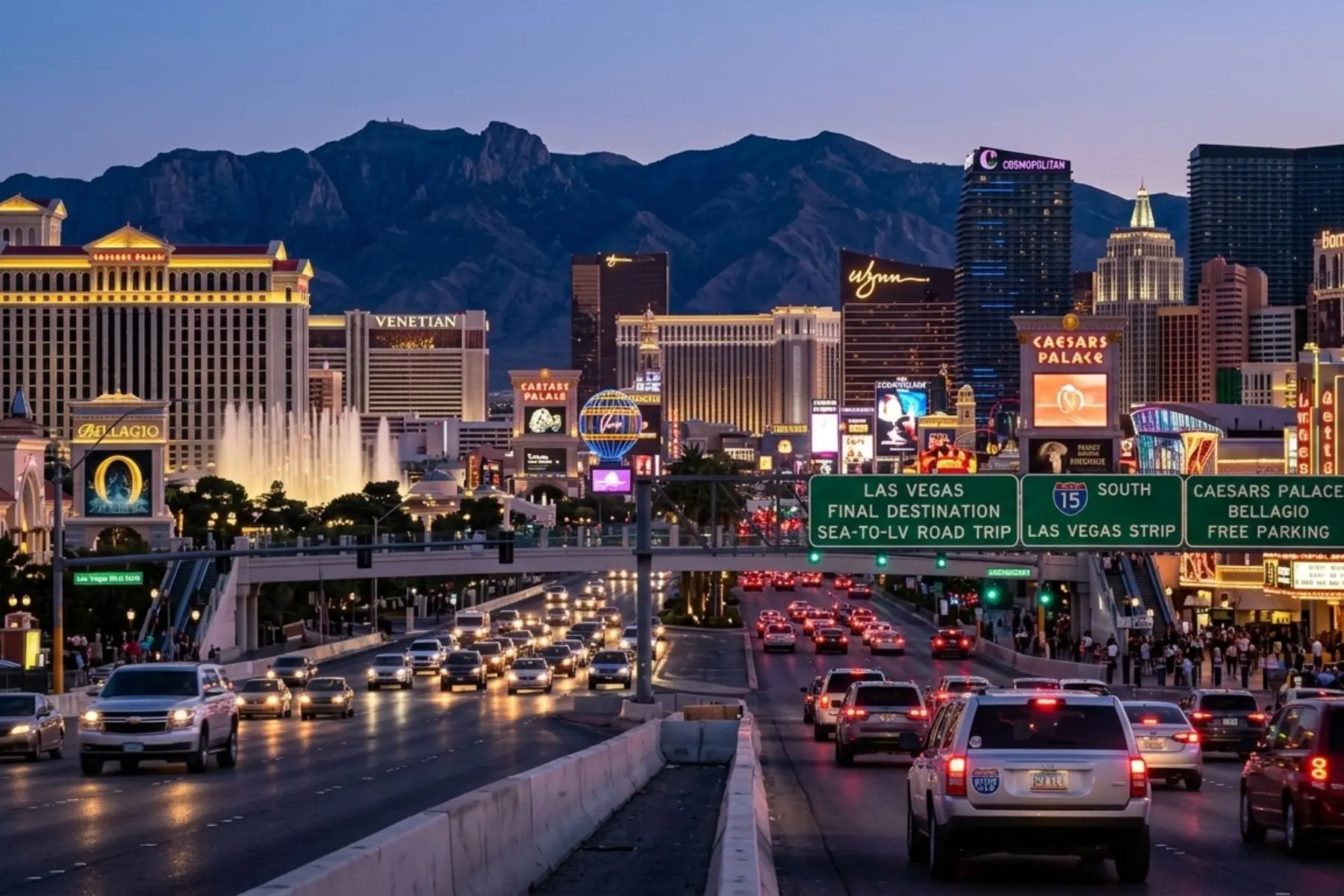
Pahrump → Las Vegas — You Made It
Take NV-160 East from Pahrump. The highway crests the Spring Mountains at 5,500 feet and descends into the Las Vegas Valley — your first full Strip view appears suddenly as you come over the ridge. It is a genuinely dramatic arrival.
Day-Trip Options From Las Vegas:
- Red Rock Canyon National Conservation Area — 26 miles west of the Strip.
- Valley of Fire State Park — 55 miles northeast via I-15.
- Hoover Dam — 30 miles southeast via US-93.
- Grand Canyon West Rim (Skywalk) — 125 miles from Las Vegas.
Flying Home from Las Vegas?
Book your departure car service from Seattle before you leave. Our network can arrange ground transportation directly from LAS to your Strip hotel.
Yosemite National Park is frequently listed in Seattle–Las Vegas road trip articles, but it sits 280+ miles off the direct I-5 route.
If Yosemite is a priority, build 2 extra days into your itinerary and budget for the detour via CA-120. It is absolutely worth the extra mileage — but go in knowing it's a significant addition, not a roadside stop.
Permits, Entry Fees & What to Book in Advance
Failing to book permits in advance is the single biggest trip-ruining mistake on this itinerary. Crater Lake, Death Valley, and Rainier are manageable without advance reservations for most of the season – but the parks listed below require reservations during peak summer months.
The America the Beautiful Interagency Annual Pass costs $80 and covers entry to all National Park Service and US Forest Service sites for one full year. On this road trip alone it covers: Mount Rainier ($35), Crater Lake ($35), Lassen ($35), Death Valley ($35) — a total of $140 in entry fees. The pass pays for itself in savings before you cross into Oregon. Buy it at recreation.gov or at any park entrance.
| Location | Entry Fee | Advance Booking Required? | Where to Book |
|---|---|---|---|
| Mount Rainier | $35/vehicle (7 days) | Yes - Paradise corridor on busy summer weekends | recreation.gov |
| Columbia River Gorge | Free (Multnomah Falls parking: $2/vehicle) | Yes - Multnomah Falls timed parking permit in summer | recreation.gov |
| Crater Lake | $35/vehicle (7 days) | No - but Wizard Island boat tours must be reserved | craterlakelodges.com |
| Lassen Volcanic | $35/vehicle (7 days) | No - walk-up entry available | nps.gov/lavo |
| Lake Tahoe (Emerald Bay) | $15/vehicle (state park) | No - first-come first-served | reservecalifornia.com |
| Death Valley | $35/vehicle (7 days) | No - self-pay at entrance kiosks | nps.gov/deva |
| Red Rock Canyon, LV | $20/vehicle | Yes - timed-entry required Feb–Nov | recreation.gov |
Full Trip Budget Breakdown
Listed below is an estimate of the cost of this trip based on one vehicle and two passengers sharing expenses. Below are current pricing estimates for 2026 –
not optimistic estimates.
| Expense Category | Budget Range (7 Days) | Notes |
|---|---|---|
| Fuel | $220 – $320 | ~1,150 miles at 28–35 mpg at $3.80–$4.20/gallon (CA). SUVs cost more. |
| National Park Passes | $80 | Covers $140 in entry fees (America the Beautiful Pass). Saves $60 vs. paying at each gate. |
| Lodging (6 nights) | $540 – $1,200 | $90–$200/night range; South Lake Tahoe casino hotels are budget-friendly. |
| Food & Drinks | $350 – $700 | $50–$100/day per person. Pack a cooler for park days — restaurants near parks are expensive. |
| Activities & Tours | $80 – $250 | Crater Lake boat tour ($45), Hoover Dam tour ($30), Skywalk ($60+). |
| Emergency Fund | $150 – $300 | Roadside assistance, unexpected accommodation, tire repair. Don't skip this. |
| Estimated Total (2 passengers) | $1,420 – $2,850 | Per vehicle. Divide lodging/food costs by 2 for per-person estimate. |
Critical Safety Information
Death Valley: The Rules That Keep You Safe Death Valley is genuinely dangerous in summer. The park receives an average of 400,000 visitors per year – and emergency rescues happen every season. Follow these rules without exception:
Death Valley Summer Safety — Non-Negotiable Rules
Carry at least 4 liters of water per person per day
— more if you plan any hiking at all
Never hike between 10am and 4pm in summer
— ground temperature on the valley floor can reach 200°F, causing rapid overheating even at air temperatures of 115°F
Fill your gas tank in Beatty, NV before entering
— the 90-mile fuel gap between Beatty and Furnace Creek is real. Running dry in summer is a life-threatening situation
Tell someone your exact route and expected exit time
— cell signal disappears for 50-mile stretches throughout the park
If your car overheats:
pull over, turn OFF the air conditioning, turn the heater to maximum, and run the engine at idle. This draws heat away from the engine and into the cabin. Do not turn the engine off immediately
Know the nearest emergency facility:
Desert Springs Hospital, Pahrump (37 miles from Furnace Creek), and Ridgecrest Regional Hospital (50 miles west via CA-190)
What to Pack — Complete Road Trip Checklist
Road Trip Preparation Checklist
Vehicle & Safety Essentials
- Tire pressure gauge and portable inflator
- Jumper cables or jump starter battery pack
- Basic tool kit (wrenches, screwdrivers, zip ties)
- Emergency reflective triangles or road flares
- 2-gallon water jug for Death Valley fuel gap stretch
- Offline maps downloaded (Google Maps, maps.me)
- Roadside assistance membership (AAA or equivalent)
- Physical paper map of CA and NV — cell signal gaps are real
Personal Gear
- 4+ liters of water per person for Death Valley day
- Sunscreen SPF 50+ and wide-brim hat
- Layers — temperatures swing 50°F between Rainier and Death Valley
- Hiking boots and moisture-wicking socks
- Rain jacket or wind shell
- First aid kit including blister treatment and ibuprofen
- Headlamp with spare batteries
- Cooler with ice for snacks and the Death Valley stretch
- Power bank for phone — car outlets are not always reliable
- Camera or phone tripod — you'll regret hand-held shots at Badwater Basin sunrise
Start Your Road Trip the Right Way: Luxury Departure From Seattle
If you’re flying into Seattle before the road trip – arriving at Sea-Tac after a long flight, picking up a rental vehicle, and immediately merging onto I-5 South – you’re starting one of the great American road trips already tired. There’s a better way to begin.
Seattle Black Limo provides professional airport transfers from Sea-Tac to any Seattle hotel or rental car facility in a clean, comfortable luxury vehicle. Arrive rested, get a full night’s sleep in Seattle, and depart for Mount Rainier fresh on Day 1. Our fleet includes the Cadillac Escalade ESV and Mercedes Sprinter Van for groups traveling together — ideal for road trip groups who want to consolidate the first airport leg.
Returning from Las Vegas by air? Our point-to-point service and hourly charter options in Seattle mean you have seamless ground transportation waiting when you land back at Sea-Tac, no matter what time your flight gets in.
Start Your Road Trip Right - Book Luxury Transport From Seattle
Arrive at Sea-Tac, transfer to your hotel in comfort, and wake up ready for Mount Rainier. Seattle Black Limo's chauffeurs serve Sea-Tac Airport 24/7 - flight tracking always included.
Frequently Asked Questions
How far is it from Seattle to Las Vegas by road?
The driving distance from Seattle to Las Vegas is approximately 1,150 miles via I-5 South through Portland, Medford, Redding, and Death Valley. The eastern alternative via US-97 South and US-395 through Reno and Nevada is slightly longer at approximately 1,200 miles. Both routes take 17–19 hours of total driving time — spread comfortably across 6–7 days.
How many days should I plan for a Seattle to Las Vegas road trip?
Plan at least 7 days to experience the major stops without rushing: Day 1 at Mount Rainier, Day 2 at Columbia River Gorge and driving to Eugene, Day 3 at Crater Lake, Day 4 at Lassen Volcanic and Redding, Day 5 at Lake Tahoe, Day 6 through Death Valley to Pahrump, Day 7 arriving Las Vegas. A compressed 5-day version is possible but leaves almost no time at any national park.
What is the best route from Seattle to Las Vegas?
The most popular route follows I-5 South through Portland, Eugene, Medford, and Redding, then turns east via CA-190 through Death Valley before joining I-15 into Las Vegas. The scenic eastern alternative uses US-97 South from Yakima through Bend, Oregon, then US-395 South through Reno and US-95 to Las Vegas. I-5 offers more services and the ability to detour to Crater Lake; US-97/395 is more remote and dramatic through Oregon’s high desert.
Do I need a permit to visit Yosemite on this road trip?
Yes — and note that Yosemite is a 280+ mile detour off the direct Seattle–Las Vegas route. If you include it, plan 2 extra days. Yosemite Valley and Tuolumne Meadows require timed-entry reservations from late May through early September. Permits cost $2 per vehicle and release 7 days in advance at 8:00am Pacific Time at recreation.gov. They sell out within minutes on peak dates — set a phone alarm.
Is it safe to drive through Death Valley in summer?
Death Valley is manageable in summer with proper preparation — but it demands respect. Carry at least 4 liters of water per person, fill your tank completely in Beatty, NV before entering (the 90-mile fuel gap to Furnace Creek is real), download offline maps before losing cell signal, and never hike between 10am and 4pm. If your car overheats: stop, turn off AC, run the heater on max to cool the engine, and wait. The nearest emergency hospitals are in Pahrump (37 miles east) and Ridgecrest (50 miles west).
How much does the Seattle to Las Vegas road trip cost?
A realistic 7-day budget per vehicle runs $1,420–$2,850 including fuel ($220–$320), the America the Beautiful Annual Pass ($80, covers all park entries), lodging at $90–$200/night, food at $50–$100/person/day, and activity costs. The America the Beautiful pass covers $140 in park entry fees on this route alone — buy it before you leave.
When is Crater Lake’s Rim Drive open?
Crater Lake’s Rim Drive is typically closed from mid-October through late June due to snowpack. The road usually opens by late June or early July depending on winter snowfall — but sections can close temporarily even in July after unusual summer snowfall. Always check the current road status at nps.gov/crla on the morning you plan to visit. The park entrance and lake viewpoints remain accessible year-round even when Rim Drive is closed